 |
Click on a neighborhood name on the map above to view individual neighborhood information (pdf format) 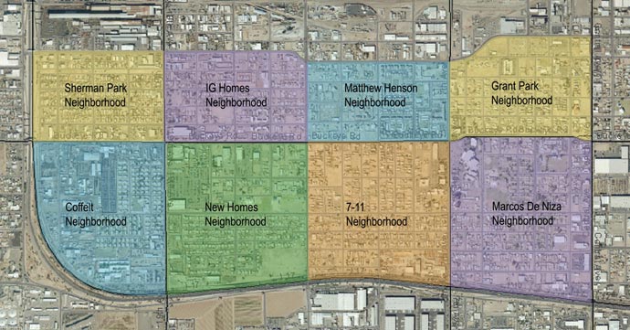 Click here to view "Central City South (CCS) At a Glance" full report CENTRAL CITY SOUTH CONTEXT Central City South is an area approximately 2 square miles, southwest of Downtown Phoenix, bounded by the Pacific Railroad tracks on the north, the Maricopa Freeway (I-17) to the west and south and Central Avenue on the east. This community is very diverse it is part of the City of Phoenix Enterprise Community/Enterprise Zone and is composed of eight different neighborhoods: Grant Park, Marcos de Niza, Seventh-Eleventh, Matthew Henson, New Homes, IG. Holmes, Sherman Park and Coffelt; with nine different neighborhood associations. This area which has historically been a low income, minority community continues that trend in 2009. In the last census done in 2005 Central City South had approximately 10,157 residents: Hispanic - 7,741 residents (76.2%) Non-hispanic White - 426 residents (4.2%) Non-hispanic Black - 1,658 residents (16.3%) American Indian/Alaskan Native - 138 residents (1.4%) Asian - 103 residents (1.0%) Native Hawaiian/Pacific Islanders - 3 residents (0.0%) Two or more Races/Other - 89 residents (0.9%) Source: 2000 U.S. Census Summary File (City of Phoenix Planning Department) |
|